The purpose of this post is to help family members find my Grandfather’s grave site. We wrote it because the site was surprisingly hard to find on the day we went.
Contents:
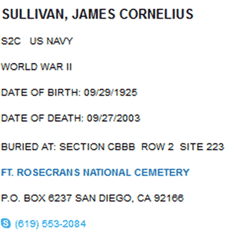
1. Grave Site Location:
(Back to Contents)
Fort Rosecrans National Cemetery,
Section CBBB, Row 2, Site 223
San Diego, CA 92166
________________________________________________
2. Maps and Directions:
(Back to Contents)
Getting there from Grandma’s
Google Maps directions from Grandma’s
From Brookview Village Parking Lot (about 35 minutes):
- Right onto Pomerado Rd. to Poway Rd.
- Right on Poway Rd. to I-15 South (on right) towards San Diego
(When you get to Miramar Marine Base stay right) - I-15 to 163 South
(take the right fork to 168) - 163 South to I-8 West
(I-8 will be on right after Mission Valley) - I-8 West to Sunset Cliffs Blvd (LEFT)
– STAY LEFT ON SUNSET CLIFFS BLVD. AND VERY SHORTLY BEAR LEFT ONTO NIMITZ BLVD - Nimitz (about 6-7 blocks) to Chatsworth Blvd ( Turn Right)
- Chatsworth Blvd (about 12 blocks to end) to Catalina Blvd (Turn Left)
- Catalina Blvd all the way to Fort Rosecrans National cemetery
(Catalina Blvd. becomes Cabrillo Memorial Dr. (Route 209 ))
(After you pass Woodward Rd. the cemetery is a little way after that) - Third entrance on right
- Drive towards the ocean and make left at the end
- Park in the circle under the shade tree
- See photos below to find the grave
Section CBBB, Row 2, Site 223
Fort Rosecrans National Cemetery:
My Grandfather’s Grave Site:
https://mapsengine.google.com/map/viewer?mid=z-Fq9AasxQKM.kQEaAYjysEkw


3. VA Grave Site Locator Links
(Back to Contents)


0 Comments